
Molonglo
Gorge, A.C.T.
[Note:
in the interests of image quality, I have limited the level of compression
of the jpeg images on this page. As a result it may be slow to load.]
Date:
4 October 1998
Location:
The Molonglo* Gorge Nature Reserve, in the north east of the Australian
Capital Territory, about 20 km from the centre of Canberra.
Description:
The Molonglo River rises in the ranges 50 km to the southeast of Canberra.
It heads northwards through agricultural country, then turns west towards
Canberra, to feed Lake Burley Griffin which bisects the city. Further
downstream it joins the much larger Murrumbidgee River.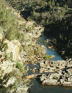 On its way from its source to the lake, it cuts through the Cullarin
Block, a geological horst formation that rose through crustal movements
above the surrounding country, starting over 15 million years ago. The
river has eroded a course down through this block over the ages. It
now flows through a narrow gorge for several kilometres.
On its way from its source to the lake, it cuts through the Cullarin
Block, a geological horst formation that rose through crustal movements
above the surrounding country, starting over 15 million years ago. The
river has eroded a course down through this block over the ages. It
now flows through a narrow gorge for several kilometres.
The river has cut through
sandstone and mudstone laid down on the ocean floor during the Ordovician
period, over 450 million years ago. The bedding of these rocks is clearly
evident in places, though the strata are now tipped nearly on their
sides.
The gorge runs east-west,
with steep sides that rise in places sixty metres (200') from the river
bed. Despite its proximity to Canberra, it is still quite a wild place.
Although it is a relatively dry area (630 mm or 25" per year, and
with much variation from season to season), the water concentrates in
a number of small, steep creeks that flow intermittently into the Molonglo.
Among the other vegetation that is characteristic of this type of Bush,
it is home to several species of dry land ferns. It was these ferns
I was looking for when I spent an afternoon recently walking through
the gorge.
The
walk:
The walking track along the gorge starts at a car park at the western
end. It follows the river bank for some hundreds of metres before climbing
up the hillside. Along the gorge, the track follows the river, sometimes
high above it, at other times right beside it, for about 4 kilometres
(as the crow flies!) until the terrain opens out into flatter country.
It is quite an awkward trek if you are in any way limited in where you
can walk, but most reasonably healthy people can manage it if they take
the time. In summer time it can get very hot, so taking drinking water
is prudent. The river at this point carries runoff from the nearby town
of Queanbeyan, and still possibly some heavy metals from the old mines
upstream at Captain's Flat, so it is probably best not to drink it!
Our walk through the gorge
was during the current "la Niña" period of above average
rainfall, so the countryside was lush and green. Mosses were plentiful
on the hillsides and rocky slopes, under a canopy of dry sclerophyll
open woodland, principally Eucalypt (several species), Acacia and Black
Cypress Pines (Callitris endlicheri).
[You can see the Black Cypress Pines in the upper half of the photograph
at the top]. As it was early spring, the first of the native wildflowers
were blooming, mainly Early Nancy (Wurmbea
dioica)and Creamy Candles (Stackhousia
monogyna) and an occasional Native Bluebell (Wahlenbergia
spp.).
To find the ferns in this
dry country, you must look for the right niche environments. This means
sites that are not only moist but continuously so, even in dry periods.
If you know where to look, the ferns are quite plentiful. On the open
hillsides among the rocks, as the path leads into the gorge proper,
there are one or two clumps of the frost-hardy Bristly Cloak Fern, Cheilanthes
distans. These are quite common in areas that have not
been overgrazed in the drier parts of the Territory, and not unexpected.
They are quite common in the Kowan Hills that form part of the Cullarin
Block, through which the river cuts.
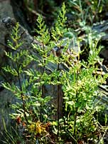
 A
few hundred metres along the track and into the gorge, the hillsides
grow increasingly steep, verging on vertical rock faces in places. Among
the tangled undergrowth, moss and grasses at the bottom of the cliffs,
the first ferns that are distinctly different from the usual dry-country
species start to appear: the Sickle Fern, Pellaea
falcata. Clumps of these ferns show the usual erect,
denuded black stems of old plants, and other fronds with mature pinnae,
indicating that the recent severe drought has not affected this immediate
ecological niche. Further along the gorge, in one of the tributary creeks,
an altogether different habitat form of this fern appears, as you'll
see below. A
few hundred metres along the track and into the gorge, the hillsides
grow increasingly steep, verging on vertical rock faces in places. Among
the tangled undergrowth, moss and grasses at the bottom of the cliffs,
the first ferns that are distinctly different from the usual dry-country
species start to appear: the Sickle Fern, Pellaea
falcata. Clumps of these ferns show the usual erect,
denuded black stems of old plants, and other fronds with mature pinnae,
indicating that the recent severe drought has not affected this immediate
ecological niche. Further along the gorge, in one of the tributary creeks,
an altogether different habitat form of this fern appears, as you'll
see below.
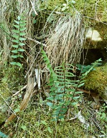
After following the river
bank for some way, the track heads uphill, into the tree and shrub-covered
slopes above the cliffs. 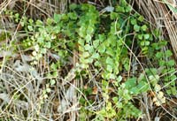 The
terrain is still quite steep, but there is a distinct overcanopy that
affords ferns a less exposed environment than lower down. Among the
grasses and rocks, you can see the first of numerous clumps of Necklace
Fern, Asplenium flabellifolium.
This is a hardy little fern that grows in crevices in the rocks in drier
areas, or among the moss and grass in more sheltered locations. It is
very widespread in the Canberra region, and is found in dry Eucalypt
forest and up into the high rainfall areas of the mountains. In the
Molonglo Gorge it is the most common fern. The
terrain is still quite steep, but there is a distinct overcanopy that
affords ferns a less exposed environment than lower down. Among the
grasses and rocks, you can see the first of numerous clumps of Necklace
Fern, Asplenium flabellifolium.
This is a hardy little fern that grows in crevices in the rocks in drier
areas, or among the moss and grass in more sheltered locations. It is
very widespread in the Canberra region, and is found in dry Eucalypt
forest and up into the high rainfall areas of the mountains. In the
Molonglo Gorge it is the most common fern.
The track maintains a more
or less uniform height above the river for some distance, and not long
after the Necklace Ferns become abundant, here and there tucked into
crevices in the rocks, clumps of the tiny Blanket Fern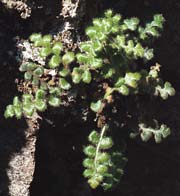 ,
Pleurosorus
rutifolius start to show. A frond I looked at of one
of these showed that - at least for the plant in question - the fern
was in fact the closely related species, Pleurosorus
subglandulosus. The only way to distinguish these species
is with a strong hand lens, which shows the tiny glandular tips of the
numerous hairs that cover the surface of the pinnae. There is debate
about whether the two species are in fact distinct. The subglandulosus
variant has not been previously recorded in the Capital Territory. The
specimen shown here is about 6 cm (2.4") across. ,
Pleurosorus
rutifolius start to show. A frond I looked at of one
of these showed that - at least for the plant in question - the fern
was in fact the closely related species, Pleurosorus
subglandulosus. The only way to distinguish these species
is with a strong hand lens, which shows the tiny glandular tips of the
numerous hairs that cover the surface of the pinnae. There is debate
about whether the two species are in fact distinct. The subglandulosus
variant has not been previously recorded in the Capital Territory. The
specimen shown here is about 6 cm (2.4") across.
About half way along the
gorge, dry gullies head off northwards from the main stream.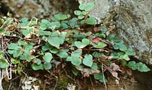 They are quite deep and both the terrain and the tree canopy provide
shelter from frosts and wind. Such gullies are always interesting places
to look for ferns in the drier areas of the region. These are no exception.
Among the rocky outcrops along one of the creek beds, there are two
or three examples of an unusual form of Pellaea
falcata. The fronds are short and the pinnae are short
and broad. It is not clear whether these are just a habitat form of
the species, caused by the scarcity of moisture in the dry gully, or
perhaps Pellaea paradoxa. Either
way they are quite different in appearance from the specimens along
the main path.
They are quite deep and both the terrain and the tree canopy provide
shelter from frosts and wind. Such gullies are always interesting places
to look for ferns in the drier areas of the region. These are no exception.
Among the rocky outcrops along one of the creek beds, there are two
or three examples of an unusual form of Pellaea
falcata. The fronds are short and the pinnae are short
and broad. It is not clear whether these are just a habitat form of
the species, caused by the scarcity of moisture in the dry gully, or
perhaps Pellaea paradoxa. Either
way they are quite different in appearance from the specimens along
the main path.
 From
here on, the terrain and vegetation along the path along the gorge remain
much the same until the gorge widens and the country becomes flatter.
As the hillsides become less steep, the drier country ferns become more
evident, particularly Cheilanthes
austrotenuifolia and C.
sieberi. Small clumps of both can be seen among the rocks
and grass on the hillsides. The tree canopy is thinner here, too, and
the ferns become increasingly scarce as you reach the point where the
gorge has become a broader river valley. From
here on, the terrain and vegetation along the path along the gorge remain
much the same until the gorge widens and the country becomes flatter.
As the hillsides become less steep, the drier country ferns become more
evident, particularly Cheilanthes
austrotenuifolia and C.
sieberi. Small clumps of both can be seen among the rocks
and grass on the hillsides. The tree canopy is thinner here, too, and
the ferns become increasingly scarce as you reach the point where the
gorge has become a broader river valley.
Finale:
In total, the gorge is about 3 or 4 km in length. The path itself is
a bit longer. The unusual vegetation - particularly the Black Cypress
Pines more common in the drier plains country to the west of Canberra
- is reflected in a distinctive fern flora. The ferns are nowhere common,
and the reader should not expect to see them popping out from behind
every rock, but they are quite plentiful, nonetheless. And like
all dry country ferns, their rhizomes find moisture deep in the rock
crevices. As a result, they do NOT transplant successfully,
nor is it legal to remove them - not even to collect specimens, without
a permit - so leave them where they are, so that others may enjoy them
too.
Fern
species noted and frequency (1-5):
- Asplenium
flabellifolium
(5)
- Cheilanthes
austrotenuifolia
(4)
- Cheilanthes
distans (1)
- Cheilanthes
sieberi (3)
- Pellaea
falcata (1 or
3)
- Pellaea
paradoxa ? (3)
- Pleurosorus
rutifolius /
subglandulosus
(3)
Notes:
The 'frequency' value here relates to how widespread the occurrence
is of the species, taking into account reasonable habitat availability.
'1' means only one or two isolated occurrences, '5' means found in every
likely habitat. The identification of the Pellaea
species is uncertain, as it is not clear that one can differentiate
P. paradoxa and P.
falcata habitat variations, if, indeed the species are distinct.

 David
Nicholls David
Nicholls
October 1998
*[Pronunciation note: for
those not familiar with the area, 'Molonglo' is usually pronounced 'mah-LONG-glow']
|